


Drone footage reveals extent of wildfire damage on moorland
Drones have captured footage showing the extent of a wildfire that burnt hundreds of hectares of farmland in North Wales for four weeks earlier this summer.
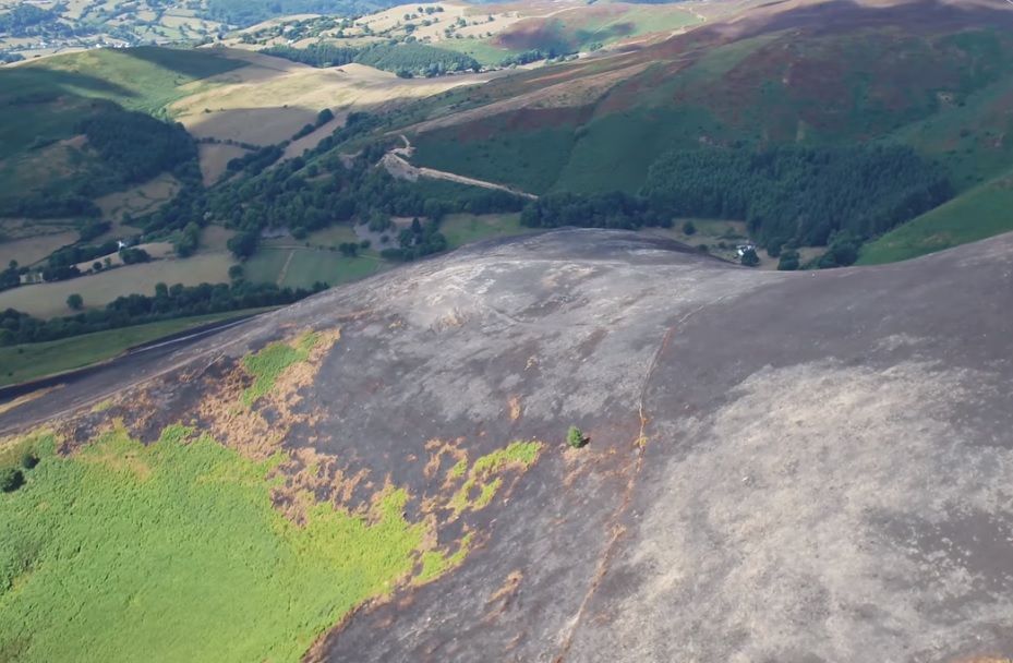
The fire on Mynydd Llantysilio, began in July, at the height of this summer’s heatwave.
Initial surveys reveal that 247 hectares (610 acres), the size of about 247 rugby pitches, has been burnt and there is little vegetation left in the area.
The mountain is a Site of Special Scientific Interest (SSSI), and provides grazing areas for local farmers.
It is also an important heather moorland habitat, and is home to rare birds like the black grouse and the curlew.
Natural Resources Wales (NRW) worked with North Wales Fire and Rescue Service (NWFRS) to cut back vegetation and create fire breaks to try and stop the fire spreading.
The groups will now work together with landowners and farmers to assess the damage, and plan what needs to be done to try to restore the area to its former glory.
Nick Thomas, Operations Manager for North East Wales NRW said: “Mynydd Llantysilio is really important to both people and wildlife and over the last five years we have worked with Denbighshire County Council, local farmers and others to improve the vegetation for wildlife and grazing.
“The thin mineral soil is normally covered by heathland vegetation like heather, bilberry and gorse.
“There are also some pockets of deeper peat that have been particularly badly affected by the fire. In places it has been completely burnt away, exposing a sandy sub-soil and rock.
Mr Thomas added: “We anticipate that some heathland plants will grow back from roots that have survived the fire or from the seeds. However, the peatland areas are likely to take much longer to re-vegetate and some areas may not recover naturally."
Mynydd Llantysilio is common land. It is part of the Berwyn and South Clwyd Mountains Special Area of Conservation (SAC) and the Clwydian Range Area of Outstanding Natural Beauty (AONB).
The wildfire follows news a similar situation for farmers on Saddleworth Moor, West Yorkshire who are left facing bills running into tens of thousands of pounds after around 5,000 acres of their land was turned into "black desert" due to a devastating fire.


